Sunday, July 31, 2011

One gorge, two gorges, three gorges, MORE

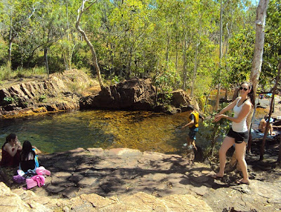
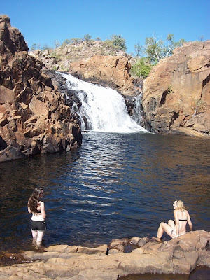
Gorges, Gorges and more gorges. It is suppose to be the dry season up in the Northern Territory. Every gorge has a waterhole and amazingly fast flowing waterfalls.


This top end country is free from drought with continual crystal clear fresh water!


Dave did find out the hard way when he drunk a few mouthfuls DOWN stream of where at least 50 odd people were swimming. That afternoon, night, and next morning was not the best time he’s had on the trip and so, with a lot of Buscopan, Gastrostop, Nurofen, and plenty of water he was able to flush whatever bug he had out of the system.

"not a smart move boy" Dad pronounced

Few days previously, he was able to do a 9km walk with me along the Katherine Gorge Ridge.

good lunch spot


In our stop at Katherine we randomly bumped into our friends Tom and Amy on their way north to Darwin after just completing the Gibb River Road. We got a few helpful tips as this was on our list of tracks to do. We ended up hanging with them for that afternoon at Edith Falls swimming in the plunge pools and taking extra long walks to find even more waterfalls.


We drove more north into the Litchfield National Park not far out of Darwin known for its beautiful environment and its flowing waterfalls. After saying goodbye to Tom and Amy a day later we bumped into our other friends Tim and Nat at one of the rock pools. Lying in the sun trying to get of our white horrible tans they peered over the top of us; initial shock of these random people then absolutely glad we had someone to share the National Park with.


All the falls and plunge pools we’ve been to have all been fresh water which as most people know, as being crocodile territory; freshies and salties. All these waterways allow swimming unless there has been a sighting of any type of crocodile. But things do seem to slip between the lines. After visiting the NP, a day later in the NT newspaper told of a lady receiving bite wounds from a salt water crocodile not far from where we were swimming. Note to self: only swim when it says its “open” and when there is a hell of a lot of people around.


Katherine Gorge - Dave..be careful..there are crocs about
..whats that log like shadow at the bottom ??? :\

Smart in the NT...They weld the signs into place.
One street sign that's not coming home with us

Saturday, July 30, 2011

Mataranka Springs - where life is good

It was only a short 161km drive to our next destination. I had been looking forward to this place after seeing so many pictures in Brochures and Camping books.  Picture this:


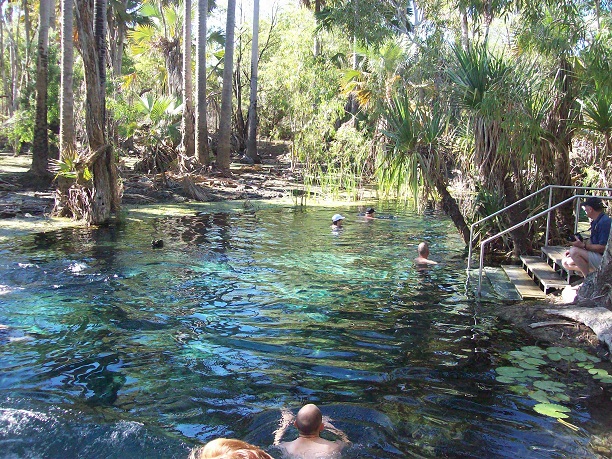
That’s where we planned to stay. The Homestead of Mataranka was home to one of the nicest thermal pool in the area. It boasted a comfortable 35 degree crystal clear pool surrounded by lush palm trees and amazing wildlife. We starting thinking about the whole experience and enjoyed the thought of where we were and what we were doing; in the middle of the desert we lye swimming in an oasis covered by palm trees almost believing we were in another country.  During our time there we ended up jumping in 3 times during the day and once at night. Probably after a collection of 6 hours in the water our skin felt amazing from all the calcium and other minerals in the water; they did say it would shave years off you.
We felt younger

After all that thermal pool swimming we decided to...go to more thermal pools. Just up the road were Bitter springs which had a more natural landscape. This thermal river had a beautiful current which was super relaxing to float down which in my opinion made it better than the developed Mataranka Springs.


I wasn't all that sure. They did say swimming with Fresh Water Crocs is OK...maybe.

Thursday, July 21, 2011

The Daly Waters PUB

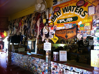
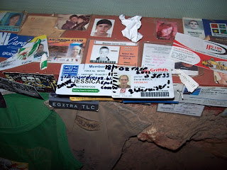
Heading from Tennant Creek our stop over for the night was at Daly Waters. We’ve been told to stay at this little town in the middle of nowhere by quite a few people. Not sure of what to expect we drove in off the highway to investigate. At Daly Waters there is a caravan park and a Pub, that’s it, but truly that’s all anyone would ever need. The pub is the oldest one in the Territory and basically better than all the outback Pubs we’ve been to. It had more bras and more ID cards hanging up than William Creek, more country artefacts than Oodnadatta, Marree, and Kingoonya Pubs put together, and unlike any others had the most remote traffic light and parking metres.


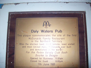
But to top it all off Daly Waters Pub had the first ever McDonalds Restaurant in the Northern Territory; the Plaque also states:
“Also the shortest lived, most remote, least visited, and the most limited menu McDonalds ever built and demolished in the world”
In the Pub History...look near the ATM

The town was also known for having the first international airport in Australia when the town was used as a rear guard base during the bombing of Darwin by the Japanese in WWII. This little but unique town was certainly worth the visit especially if your after a good cold beer and a hearty meal. Happy hour was ‘toss a coin against the bar’; pick heads for tails in a toss and if you get it right the beer was FREE. Dave got 3 out of 4 right which made for a cheap drinking afternoon. Their world famous Beef & Barra meal included a massive porterhouse steak and filets off a barramundi which was worth the extra money. Later in the night we had free entertainment with old slim dusty songs, poems of Snowy River and their horses, tales of mustering and horse breaking, songs of the Australian flag, and everything patriotic to this country.
The caravan park was excellent and because a mix up with the Irish receptionist, instead of paying $14 a night we ended up paying only $4. Haha another one up for us.

Wednesday, July 20, 2011

Into the Tropics

It had been raining for the last 3 days, temperatures weren’t all that comfortable either plus the roof top tent was getting that moist smell inside. It was time for change, time for the sun and hot temperatures. We now head NORTH. Tim and Nat had their own little plan going to Ayres Rock and Kings Canyon but we hoped to catch up again further up the track. Stopping not far up the road at the Tropic of Capricorn there was almost an invisible line across the sky that divided the cold and wet of Alice Springs and the desert hot temperature of the north. After days in jumpers and raincoats getting back into shorts, t-shirts and more importantly thongs (with a beer) felt like heaven.
Travelling along the 87 highway it’s amazing how many caravaners and tourists are on the road. We found out the hard way when we pulled into a free rest area and found limited spaces for our 1 space vehicles. There were at least 40 vehicles ranging from wicked vans to oversized buses all scrambling for a space. We managed to slip in somewhere but now we’ve learnt to be off the road by lunch time instead of late in the arvo if we want a site.

Next day we headed for Devils Marbles but on the way we noticed a little town just south called Wycliffe Well known as the UFO capital of Australia. Expecting little we rocked up and...received little. There was a pretty cool pub with UFO pictures and newspaper articles of apparent sightings but other than that, I don’t think it’s anything like Salt Lake City and the American fanatics. It was more of an ‘I’ve been there’ sorta thing.


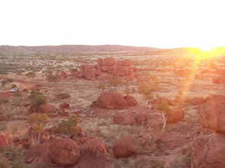
Devils Marbles was next along the road; pretty much unavoidable in dead flat country. The boulders are the remains from a 1700 million year volcano and through all the years of erosion these balls end up laying precariously balanced on top of each other. These boulders make for interesting climbing too. Camping was allowed at the Marbles but free to us as usual. We’re getting better; we even saw a ranger come in and take the envelopes...didn’t even check us. Hehe. Another $6.60 saved.


Heading even more north Tennant Creek was the next stop mainly for fuel. Our budget of $500 a week becomes very stretches in these long distances and expensive fill ups. We complained about 5c rises in Brisbane but out here our mentality changed. It becomes acceptable to pay $1.80 out in the sticks and about $1.60 on the highway. We can’t change the price so we acknowledge the plain and simple fact that we can’t go anywhere without it.


Tuesday, July 19, 2011

We head WEST

Every day is a weekend when travelling on the road. Many of time we ask each other what the day is instead of the date so now we call pretty much every day a Sunday. Though, we always know when school holidays are on when caravan park rates triple, free sites are full by lunch time, and all touristy things are taken over by kids and their persisted screaming. So, being a Sunday we packed up our things and headed west for the MacDonnalds Ranges hoping to get away from all the havoc in the caravan park. This area west of Alice Springs is known for beautiful swimming gorges and amazing area walks. Though most gorges had similar landscapes and waterholes, there was always something different about each one whether it was the trees, the width of the creek, the height of the gorge cliffs, or the amount of water in it. Each was worth the drive in.


Most of the waterholes allowed swimming but when days are averaging 15 and two jumpers still aren’t enough to keep us warm, the crystal clear waters still didn’t persuade us.  One downer was the amount of dead fish at the banks of the larger waterholes. Apparently in the colder months a bacterium grows on the gills of the fish which eventually restricts the oxygen intake.  They say it’s a natural occurrence. I say it’s a  bummer in the photos...

Along the tourist drive we did find an amazing free site overlooking most of the range which was made all the more better with free wood for a raging fire for dinner. Sitting drinking hot chocolate with a warm fire overlooking the ranges at sunset was a beautiful end to the day.


 One of the more popular places was Ormiston Gorge. Here national parks come with hot showers, free gas bbqs, and fresh drinking water all for the very low price of $6.60pp. We cruised off for some walks; dad and I up to a lookout while Dave ventured for the 4 hour walk where it was required to swim through the gorge to get to the other side. Close to freezing water up to the chest results in definite cold cramps... Dave came back to camp a little worse for wear.

With a few more gorge sightings under our belt Dave and I thought we’d go for the big gun, Palm Valley. This would have been difficult for dad so he ventured back to Alice and agreed to meet up in a few days. This track is only designed for 4WDs which did require a fair few creek crossing, very soft sandy patches, and the general 4WD angles and manoeuvres.  This was made a little more difficult because of a few days of late rain and the extra seasonal rainfall for the year. So there were deeper creek crossings, axle deep sandy patches, and steeper angles and manoeuvres. In the end we got to the camp ground not far from the actual Palm Valley. It was late in the afternoon so we had a relaxing end of the day but was soon interrupted by rain. It rained all night and all in the morning which meant the ranger was around requesting everyone to get out now because of more forecasted bad weather. So it was a horrible pack up in the rain and quick ‘let’s get out of hear’ jump in the car drive. The road was getting ripped up pretty quick as more rain meant more mud, boggy sand, and even higher creek crossings.  We got out in one piece which was expected in our troopy with 33” Maxis Muddy tyres at 20psi. So back to Alice we went.

Felling just generally low because of our failed attempted at Palm Valley, heading back to Alice didn’t help with pelting rain most of the way. Though, it is amazing what just one text message can bring. Our friends Tim and Nat were in Alice Springs! It was instant happiness. We met up at Macca’s over 2 Mates lunch meals and chatted about all our funny adventures. They recently went to Cape York and described it was wonderful and extremely stressful with their troopy handling the telegraph route mostly at a 45 degree angle. With a broken CV joint, countless scratches on the side of car because of the narrow trenches and angles the car was on, multiple tows in and out of creeks, and probably a million other things they fully completed the track. I say “hats off to them”, oh, we also felt very special when they brought a coconut all the way back from the Cape. That night, it was a mixture of wine and all brands of beer in a caravan park to catch up with well missed friends.

Monday, July 18, 2011

The Red Centre Way - continued

Further along the Red Centre way we travelled. Kings Canyon was our next stop only a short drive from our bush camp. I couldn’t remember of my last visit here but dad was keen to remind me of the walks we did and the tanny tantrums I had. Kings Canyons and its resort is a very similar set up as Ayres Rocks; general store, servo station, restaurants, resort accommodation, and Caravan Park which they can charge pretty much whatever they want. Unpowered - $19 per person and Fuel - $2.19. Sigh, can’t really do much.

I was however very impressed with the national park. Drinking water available in many places, plenty of car parks, and nice picnic area...plus it was all free. We vouched for the shorter walk first through the dry creek bed of the canyon. Though short, it was breathtaking. Looking up 100m of sheer cliff faces exposing 400 million years of sand with lush greenery at its base is something worth driving the distance.

There was however, a 7km 3-4 hour ridge walk that Dave insisted on us doing. It wasn’t a pleasant first sight when all you could see were stairs navigating up a 100m cliff face. All those gym sessions purposefully ignoring the ‘stair master 3000’ had finally come to an end. Setting aside that negative, the rest of the walk was quite leisurely. The view though was worth every bit of effort. We could walk right to the edge of the cliff, walk down into gullies with natural waterholes, and yell “cooee” hearing the echo 4 times throughout the whole canyon. That walk would easily be in my top 5 rating itself similar to Cradle Mountain, walk to the most southern point in Australia, and Mount Warning. Definite must do for any travellers. 


After a night at the resort, we headed along the dirt road again (more corrugations) for Alice Springs. This town was a first for everyone. This stop in town lasted 4 nights in a caravan park which allowed us to full up on all essentials, for me to have extra long showers, and to generally explore the town. Alice is a nice town, very touristy, pretty much the hub needed for travellers. The caravan park however, had some issues. We booked two powered sites weeks ago but when we arrived they had doubled booked one of our sites. So after some deliberation, we ended up with two cars on one site and half our money back. We thought it was a great deal, peak season rates for literally more than half the price.
Another bonus was the local Camel Cup in town.
A day of very unreliable animals, horrible bookie odds, cheap as chips XXXX gold, and entertaining locals made for a fun Aussie outback day. We lost a bit of money on the Camel ‘Bruce’ and ‘Goldy’; Bruce at the starting line tried to go backwards around the track while Goldy was out in front but lost his rider half way around. Hmmm, we’re not betting people for that reason.

Good old Brucey


Sunday, July 17, 2011

The Red Centre Way

After 600km of red dust vacuuming into the back of the car the black tar stuff was a certain sight to see. On our way to Uluru there was a 300 stretch of nothing. Knowing that a massive rock should be within sight was nowhere to be seen until the very last few kilometres. Dad and I have already been to Ayres Rock and Kings Canyon before so this trip was more for Dave (possibly a reminder for me). He was pretty excited to finally see the rock for the first time but it all seemed a bit rushed as Dave was so focused on getting to the base of the rock and attempting to climb it. It was a beautiful sunny day but we could feel the breeze pick up so it was full on pedal to the medal. There is a list that gives particular conditions that allow the national park to close the climb and in many cases it is closed due to high winds ranging above 25 knots at the summit. Dad and I remember years ago when we climbed it with mum, it was a cool breeze at the base but once we got to the top dad literally had to hang onto me or I would fall over. So, having told Dave that, he was absolutely determined to climb.


 When we arrived at the base the climb was open, we ran quickly to get within the gates and to at least touch the rock. It was a tough 100m incline to reach the chain which did give a lot of assistance. Do you remember the photo of the nut incline? It was pretty much that. I don’t even remember looking up because my head was so focused on the path in front, holding onto the chain, and not looking down (me and heights aren’t the best of friends).
Dave was behind me walking up like it was a Sunday stroll and dad was full steam ahead – he’s a bloody fit 63 year old. The further and further we climbed the more and more the winds picked up. I can really see why 35 people have died and many more have been injured. Walkers coming down weren’t even near the chain and one slip literally could mean the end. People put a lot of trust in the soles of their shoes.  Once reaching ¾ up the chain disappeared and it was replaced with a simple white line. Stopping to have a rest became difficult as the winds easily put us off balanced so only one option, keep moving. Some of the routes the white line directed were idiotic; directing people over a downhill ridge and both sides having a massive drop off didn’t quite seem right. Plus, it’s not like people are well equipped. I saw countless tourists walking up in fashion boots, thongs, and without water. No wonder the National Park and the local Aboriginal community don’t want people to climb. Getting to the top was an amazing accomplishment. The view of the Olgas and Mt Conner in the background and an endless horizon of greenery was a definite reward. The walk down from the summit was more leisurely and made for good photography. There was a drop off in walkers as we were coming down which did suggest that the climb had been closed. Dave was super happy that we got that window of opportunity.

Us at the top!


After a little rest the culture centre was the next port of call where we found out that the climb had been closed for the last 4 days and only today was it opened for 4 hours. It was closed from that afternoon and into the next morning. We were lucky.
Next morning we challenged our self to the 7km Valley of the Winds walk into the Olgas. Seeing the vibrant green colours, waterholes that were full, and the contrasting red boulders that were big as skyscrapers is something we’ll never forget. The area has had 8 times their annual rainfall which was easily seen in the environment. Bird life, wild flowers, and creeks following show how alive this country is.

That night we free camped with some other happy campers. Big fire was all in place...we certainly needed it as temperatures fell below 2 degrees. Field mice were plentiful, fat and slow enough for me to catch easily. I didn’t play my game that night...I like field/bush mice. We were lucky enough to watch an owl swop down and catch a mouse within 2 metres of us. The owl came like a slight breeze and with one grab, caught the mouse and flew off into the dark. We looked around at each other as to question if that actually happened. Where’s the camera when you need it.